
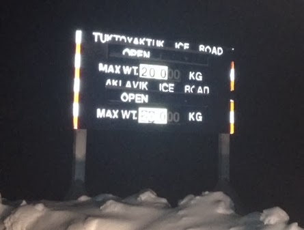
Tuktoyuktuk meaning "resembling a caribou" is 186km north of Inuvik. It's not only fun to say, it is as far north you can drive in Canada in the WINTER. (Inuvik is as far north as you can drive in the summer). You can only drive to "Tuk" 4 +/- months of the year when the MacKenzie River and the Arctic Ocean is frozen. The river and ocean create one of the many "ice roads" in the arctic and this winter-only road is actually part of the Trans Canada Highway and surprisingly well maintained. The Prime Minister of Canada was just in Inuvik a few weeks ago for the official announcement of the permanent road that is being built from Inuvik to Tuk. In aprx 3 years you will actually be able to drive from Canadian coast to coast to coast. There is a lot of controversy in town as to if this permanent road is a good idea. Not only will it bring supplies and jobs, but it will also bring drugs and alcohol to the community with a population of 900, 300 of them children.
To put this in perspective for my east coast family,Tuktoyaktuk is 7606kms (4726 miles) from Groton Massachusetts. It would take 90 hours to drive there or 1452 hours to walk per Google maps. So Uncle Mark, start walking. I'll see you in two months. Bring a coat.


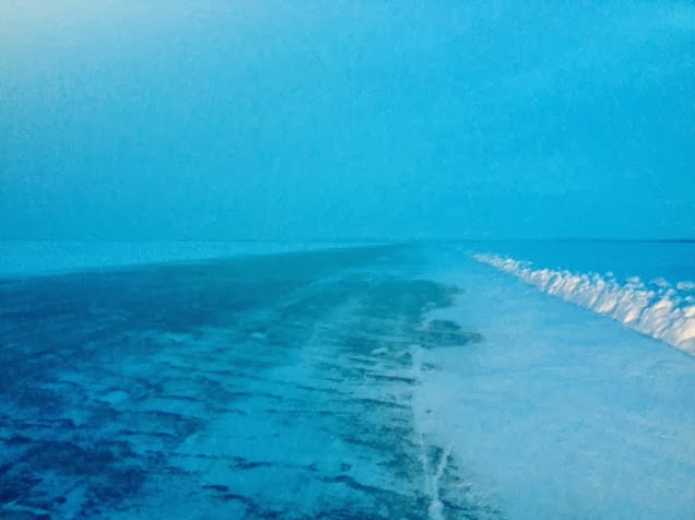
The girl that drove us warned us that we WILL at some point fishtail and/or spin out and to remain calm. She was right. For no reason, we just caught an edge and did a wide180 degree turn. The driver, remained calm which was the most important. She did not touch the breaks, just let the truck take us. This is why a) you drive down the center of the road. there is very little traffic, and b) the road is 100 feet wide. The truck just slid and to a came stop in a "poof" of fluffy snow along the snowbank. We were safe and continued on our way. Kinda fun.
The girl driving brought some of her home made white tail deer jerky for the ride. I said, "oh yah, I still have whale in my pocket" and brought out my beluga jerky. These are conversations I just wouldn't be having in Vancouver. Pretty cool.

Along the way we saw some pingos. Granted they are a bit more dramatic in the summer there are about 1500 of these landforms scattered throughout the western arctic and they are actually Canada's only National Landmarks. In an area that is nothing but flat, they really stand out. Tuk has Canada's largest pingo called Ibyuk Pingo. It reaches 160ft in height and is almost 1000ft wide at it's base. For centuries the pingos have served as navigational aids to the Inuvailuit traveling by air and water and they also use them as lookouts when hunting caribou in the tundra or whales offshore. From my understanding, they form from where lakes once were. The frozen permafrost from below pushes up the nonfrozen/pliable "dry" lake bed.
 |
| I warned you they were more dramatic in the summer! |
Another cool thing we saw was remnants of the DEW Line or the Distant Early Warning System. It was built in the 1950's to detect incoming Russian bombers and provide an early warning system for land and sea invaders. The system was developed out of an MIT study in 1952 that expressed the vulnerability of US and Canada to ariel attacks
http://en.wikipedia.org/wiki/Distant_Early_Warning_Line

 |
| The hamlet of Tuktoyaktuk, population 900 aprx |
 |
| At the one and only grocery store you can buy fox, muskrat, seal fur. Why not? |

Seal. Note the flipper holes.
 |
| I think this is a fox....on a Tonya. |
There certainly weren't many cars in this small community. I guess there is no need when you can only drive out 4 months of the year. Most everyone was traveling by snowmobile and yes, the truck of 4 out-of-town blond girls got a lot of attention. I had hopes of putting my toe in the Arctic Ocean but realized in the winter it's 40 km away due to the ice. It was cool to see boat and docks and not a drop of (liquid) water in sight.
| TransCanada Highway Monument |
 |
| Doorway of the sod houses |


We made a quick stop to the Health Center. I thought it was odd that next to the Health Center was....the cemetery. Ironic location. It was pretty against the white snow.


The big attraction in Tuk is the permafrost freezer or the "Tuk Ice House" built in 1963 for locals to store meat/food. The underground permafrost is mother natures cooler and stays a pretty consistent temperature all year round. There are 19 rooms in total divided into three hallways. It is not used for food storage any longer as people use the convenience of actual freezers or just keep things outside on their porch. It's more of a tourist attraction and a historical landmark.

I'm not sure what I expected but a 30 foot ice covered ladder into a dark whole wasn't it. I do NOT like heights and was less than impressed with the potential for falling to my demise into a stinky (fish smell) freezer. I'm not sure why I can jump out of an airplane and freefall but this was an issue. Makes no sense.
 |
| UGH |
 |
| Sherri being brave! |

I basically hugged each ladder rung with the crook of my elbow and slowly made my way down. It was totally worth it. What a sight! I wasn't expecting it to be beautiful. The top half of the walls were these amazing ice crystals that you could lose yourself in. The bottom half of the walls were ice and silt and looked like marble. Just amazing!


 |
| I could almost stand up. |
 |
| Sheri brought shots. Probably the coolest place I've done a shot of booze. Hands down. Good idea!! |
 |
| I look pretty cute for being so terrified. |
No comments:
Post a Comment